Writing a comparison with Seattle’s transit now wouldn’t be useful if we didn’t also compared the past. Seattle and New York’s pasts are actually eerily similar. In 1968, Seattle voted 50.8-49.2 to build a brand new regional transit system similar to BART or DC Metro. However, the referendum needed to pass a 60% threshold, and so the system was never built and the federal money slated for Seattle instead went to Atlanta.
Likewise, in 1968 things were looking up for the MTA. As a brand new agency with a political mandate to modernize and expand transit, in 1968 the authority published a bold plan to do just that. Unfortunately for New York, at around the same time both the New York City fiscal crisis and the system’s legacy of deferred maintenance hit, and the agency went into a death spiral trying to put out those fires. But what would it have looked like if that plan had been built out?

The map above displays some of the proposals made during that time period.

Manhattan
- The completion of the Second Avenue Line from 125 St to Hanover Sq
- A tunnel bringing LIRR trains to Grand Central

The Bronx
- Two extensions of the Second Avenue Subway
- The first would’ve seen a new express link paralleling the Pelham Line, diverging roughly where Hunts Point Av is and stopping at E 180 St before taking over the Dyre Av Line currently used by the 5.
- The second would’ve replaced the old Third Avenue Elevated in the Bronx using what is now the Metro-North right of way, going all the way to 241 St. Personally, I showed it going to Burke Av, since having two lines go to 241 St would be redundant, although it could’ve been planned to replace the White Plains Road Line north of Burke Av.
- The extension of the Concourse Line (B D) to a new intermodal terminal at Burke Av
- The extension of the Pelham Line (6) to a new intermodal terminal at Co-op City
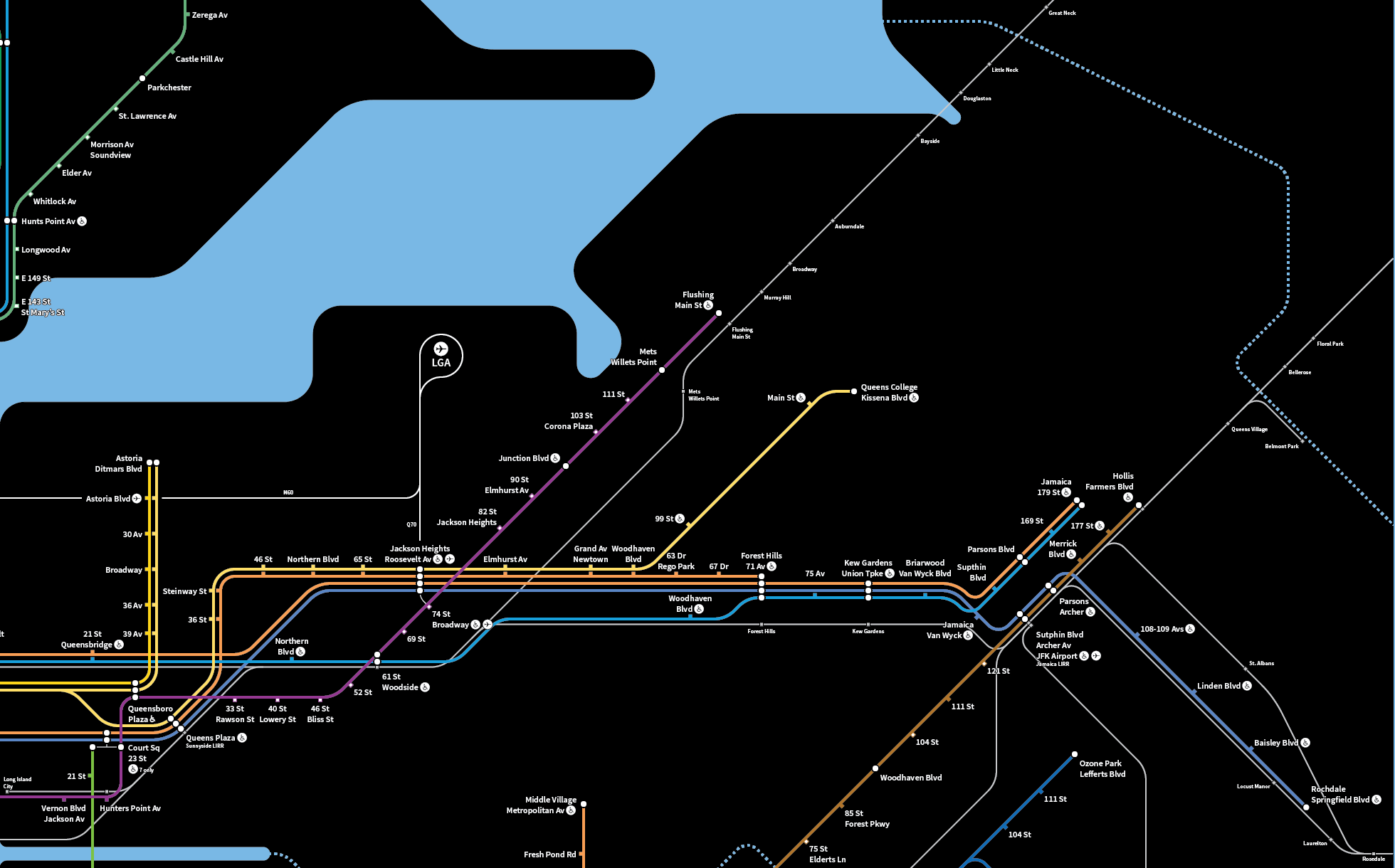
Queens
- The construction of the 63rd St tunnel and the Queens Boulevard Bypass, which would’ve allowed two tracks to relieve the Queens Boulevard Line
- The construction of a Long Island Expressway Line from Queens Boulevard to Queens College
- The construction of the Archer Avenue Line (E) to Southeast Queens

Brooklyn
- The construction of the Utica Avenue Line to roughly where Kings Plaza is now, at Avenue U and Flatbush Av
- The extension of the Nostrand Avenue Line (2 5) to Sheepshead Bay
- The rerouting and extension of the Canarsie Line (L)
- The existing line to Rockaway Parkway would’ve been rerouted over the Bay Ridge Branch and extended to Flatbush Av/Brooklyn College
- An additional branch would’ve split off after New Lots Avenue and served East New York, probably via Linden Blvd (although documentation of this particular proposal is poor)
So what would have been the impact of these new lines on an alternative, 2016 New York?
- The Lexington Avenue and Queens Boulevard Lines would be less congested.
- With both a completed Second Avenue Subway and a Queens Boulevard bypass, the two most congested trunk lines in New York would have alternate routes for commuters. That’s not to say that everyone would have a seat on these trains, but it would be much better than today’s crowded conditions.
- It would have allowed further expansion into the outer boroughs.
- Today, there is no room in the core for further expansion of service. The Second Avenue Subway would have provided an additional 2 tracks into the core, enabling another 30 trains per hour. As envisioned in 1968, the core would’ve had spurs linking the Bronx and Queens to Manhattan, providing congestion relief on intersecting lines, and a further extension south into Brooklyn would do the same. The less congested existing lines could then be extended further out to take advantage of this new capacity; for instance, the F could go further east on Hillside.
- Triboro RX would be a lot more realistic.
- The line would complete about a quarter of the route from East New York to Brooklyn College. From there, it would have been trivial to extend west to the Brooklyn Army Terminal, and north to Jackson Heights, Astoria, and the Bronx, providing an effective outer-borough bypass of Manhattan.
Unfortunately for us, this vision never came to be. Hopefully, one day New York’s leaders will be able to get together and come up with an equally promising vision of transit for the future.

Great map. It really helps me envision what transit could be like today. I noticed a minor error. In the Bronx you wrote Brooke Avenue instead of Brook Avenue. I have never seen the Queens Bypass proposal have a stop at Woodhaven Boulevard. I have documents for the plan from 1984 and there they have a stop at Northern Boulevard with a transfer to Queens Plaza, a stop at Woodside, and a new stop underneath Forest Hills. Maybe the plan changed. Thanks again.
Also, the Q70 terminates at Woodside.
There was never really a plan to have it, but I included it for my own purposes. It’d be more useful; Rego Park is a major bus hub as well as the old location of the junction with the Rockaway Beach Branch.
Maybe it was a typo, but I know that it should be located at 63 Drive-Rego Park, Woodhaven Boulevard wouldn’t work in my opinion
I am sorry for my third post, but I caught another mistake. On the 1 you wrote 236th Street instead of 238th Street.
The B should stop at 7th Avenue in Brooklyn, and you forgot the 72nd Street station on the B and the C.